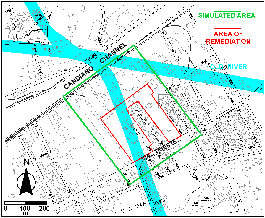
Figure 1. Location of the simulated area within which the area of remediation is placed. The trace of the old river beds are pointed out.
MIKE-SHE APPLICATION TO THE RECOVERY
PROJECT OF A FORMER INDUSTRIAL AREA IN RAVENNA, ITALY, STRONGLY POLLUTED
BY TOXIC METALS
M.Bersano Begey
HYDRODATA S.p.A., Via Pomba, 23 - 10123 Torino, Italy - E-mail: hydro@inrete.it
M.Gonella, P.Teatini
MED Ingegneria, Riviera Ruzzante, 49 - 35123 Padova, Italy - E-mail: meding@tin.it
P. Teatini
DMMMSA - University of Padova, Via Belzoni, 7 - 35131 Padova, Italy - E-mail: teatini@dmsa.unipd.it
A.Refsgard, L.Basberg
DHI, Agern Allé,5 - 2970 Hoersholm, Denmark - E-mail: anr@dhi.dk
SUMMARY
The study concerns the application of the MIKE-SHE modeling in the
project of environmental recovery of an old industrial site located in
the harbor of Ravenna (north-eastern part of Italy) where, starting from
1920, herbicides and chemical fertilizers have been produced. The production
and accumulation of chemical compounds are the causes of a strong contamination
of the area by toxic metals (Arsenic, Lead, Copper). The contamination
affects the unsaturated zone and the phreatic aquifer up to a depth of
about 3 m. A great amount of data has been collected in order to characterize
the area which extension is about 150000 m2. Hydrogeological
information has been obtained by soundings, geophysical measurements, aquifer
tests. Geochemical data have been obtained by contaminant release tests
on soil samples, and chemical analyses on soils and groundwater. Piezometric
head surveys have been performed and concurrent marine tide time-series
have been gathered. MIKE-SHE has been applied to assess the seasonal water
table gradients and the related pollution fate, with and without recovery
actions.
1. INTRODUCTION
The Municipaly of Ravenna has committed a hydro-chemical-geological study to support the guideline drawing up of the executive project of pollutant restoration in an area (Figure 1) located in the center of the town, close to the Candiano channel, where chemical compounds have been produced during the first decades of this century.
The aim of the work has been to achieve a well knowledge of the present hydrogeological and hydrochemical conditions of the site and to evaluate the efficiency of possible remediation interventions to achieve the European and national limits in the pollutant concentration, both in soil and water, allowing to convert the use of the area from industrial to residential.
The simulated porous media is characterized by three main layers, being the middle one the sandy unit of major interest. This aquifer is mainly formed by the bed of an old river that flowed through the area from 1250 to 1650 (Figure 1). The water movement module (WM) has been calibrated in order to reproduce the measured hydraulic head in 1997 and 998 using as boundary conditions a time-depended water table level calculated by an ad hoc relationship as a function of precipitation and potential evaporation reflecting the general climatic effect.
The outcome from WM for a "typical" year has been
used as input data in the advection/dispersion and sorption/degradation
modules to reproduce the pollutant specie migration and to establish the
best remediation scheme.
Figure 1. Location of the simulated area within which the area of remediation is placed. The trace of the old river beds are pointed out.
Geology
The geological reconstruction of the study area have been carried out on the basis of 66 wells drilled during different investigation campaigns. The stratigraphical characterization can be considered very precise and reliable.
Four layers have been identified (Figure 2):
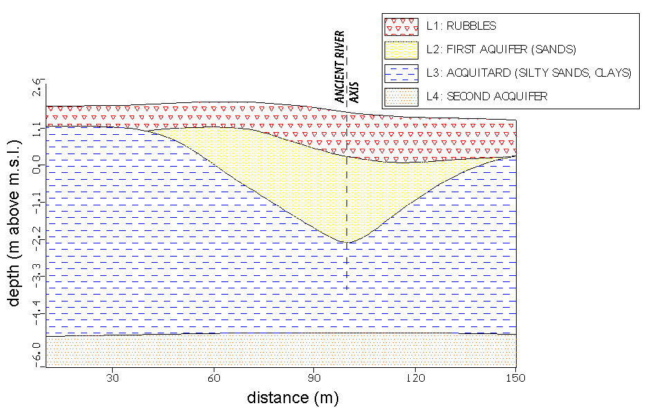
Figure 2. Geological vertical cross-section through the study area.
Further information concerning the geology of the area have been obtained
with a campaign of geophysical investigations. In particular, the method
of the multi-electrode tomography has been applied, leading to two-dimensional
resistivity measurements. Figure 3 shows a tomography section of the area.
Notice the red zones corresponding to the rubbles of layer L1 (resistivity
> 100 ohm. m),
the green zones of the sandy aquifer L2 (20-35 ohm.
m) and the silts and clays of the underlying layer L3 as the blue level
(<10 ohm.
m).
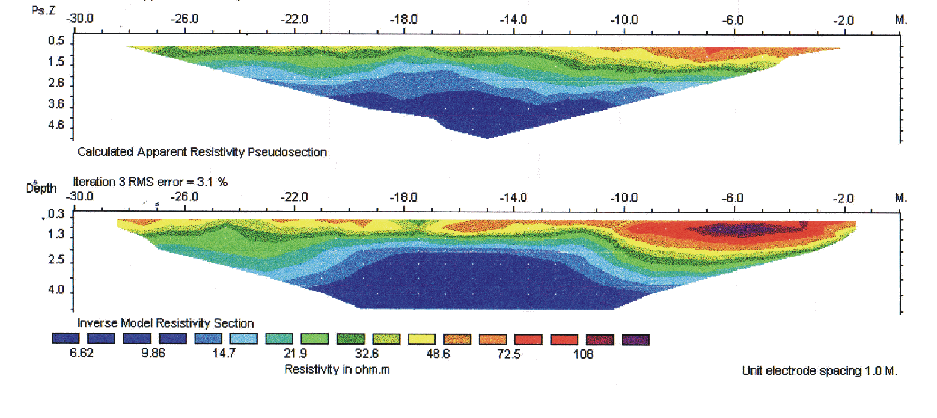
Figure 3. Tomographic vertical section through the study area.
Hydrodynamic parameters
Aquifer permeability has been assessed by 2 pumping tests and several slug tests. Pumping tests been carried out using couples of pumping/observation wells drilled along the axis of the ancient channel, where the deposits are mainly composed by medium and coarse sands. The slug tests have been performed to evaluate the permeability of the aquitard (silty sands) on the banks of the palaeo-structure.
Results from the pumping tests have been processed using Neuman's method
for unconfined aquifers [1], the most appropriate approach in fine sandy
aquifers, since it is takes into account the delayed drainage from sediments
as the water table declines during pumping. Slug tests have been interpreted
by the common Bower method [2], on the basis of the drawdown rate, measured
after a solid "slug" is instantaneously lowered into the piezometer raising
the water level. The layer permeability resulting from the in situ tests
is given in the Table 1.
|
|
|
|
|
|
|
|
|
|
|
|
|
|
|
|
|
|
|
|
Table 1. Permeability values obtained from in situ tests.
3. HYDROCHEMICAL SETTING
Contamination sources and production processes
A reconstruction of the former industrial processes in the area has been carried out in order to focus the sampling campaigns on the main "hot spots", where most of the contamination took source. Since no more signs of the original plants are present in the area, the reconstruction has involved the examination of the factory schemes and designs, by personnel expert in palaeo-industrial processes.
Soil contamination by lead and arsenic is related to the production, from the '30s to the early '50s, of lead arsenate widely used at those times as an herbicide. The main sources of contamination are identified particularly under the production plant and the not-paved shed where the powdered product was stocked, and along the railway connecting these two sectors on the factory. The presence of a very high level of copper contamination has been identified in the area of production of anti-parasitic compounds, mainly composed by copper sulphate.
Soil and groundwater quality
Contamination degree of the study area has been assessed through the analysis of 160 soil samples and 27 water samples, collected in three different sampling campaigns, with different groundwater level conditions.
The soil samples have been taken using drilling machine and continuous flight auger as sampling tool. Groundwater has been sampled by mean of vacuum pumps (with a proper purge before sampling) installed in 4" PVC piezometric wells. In both cases the EPA guide-lines have been followed.
The highest pollutant concentration in the soil has been encountered
in the samples cored at a depth ranging between 0 and 3 m. In this range
of depth, about 70% of the samples collected from the zone where the production
plants were located exceeds the legal limits for the residential use of
the area (20 mg-As/kg, 100 mg-Pb/kg). The remainder 30% exceeds the limit
for the classification of the soil as a toxic waste (100 mg-As/kg, 5000
mg-Pb/kg).
4. MODEL SET-UP
The modeling study covers an area of 380 by 500 m within which the old industrial site is located. The area extends from the Candiano channel, directly connected to the Adriatic Sea and influenced by tidal fluctuations, to Via Trieste in the Ravenna center (Figure 1).
All the available information about the geology of the area have been used to set up the geological model. The upper three geological layers have been accounted for, and a lens representing the ancient river bed has been introduced in the model setting (Figure 1 and 4). The overall simulated thickness is about 7-8m.
The modeled area has been discretized by a 8x8m grid. Two different vertical discretizations have been used. The first has been defined by the geological layers and has been adopted during the hydrodynamic model calibration; then, 8 computational layers have been introduced, with a better resolution of 0.5 m around the water table position (between the ground surface and a depth of 3 m), and a coarser discretization in the deeper part.
The main features of the flow pattern in the simulated area are quite well known from the piezometric campaigns. The hydraulic gradient is generally low, with the principal flow direction toward the channel that however shifts in the opposite direction during the dry season. In transitional period or immediately after heavy rains, mounding of the water table occurs, and the piezometric gradient reveals a more complicated pattern.
Hydrodynamic simulation have been performed by the
Water Movement module of MIKE SHE [3]. Only saturated flow has been accounted
for. Unsaturated flow has been not included, manly because the water table
is located close to the surface and, furthermore, for the high heterogeneity
of the upper unsaturated layer.
Boundary conditions
Downstream - Candiano channel boundary
The channel is influenced by tidal fluctuations, but no evidence of a significant tidal influence on the aquifer flow pattern is available from the in situ piezometric measurements. This has also been confirmed by a preliminary set of hydrodynamic simulations even if a little uncertainty exists on the degree of leakage between the aquifer and the channel. A constant head level of either -0.1 m or 0 m has been used.
Upstream - Via Trieste boundary
Field observations suggest that flow pattern in the study area are mainly influenced by this boundary. Daily value of the hydraulic head at this boundary has been calculated using the following equation:
W-SW and E-SE boundaries
No flow boundary has been applied, but is has been verified the possibility that there should be flux across parts of these boundaries.
Surface boundary - Bypass flow
The infiltration pattern in the area is complex and influenced by industrial activities. The better description of recharge pattern has been obtained using information regarding paved areas and areas in which groundwater may be recharged. A map with these two spatially distributed zones has been generated and used in the simulations.
Bottom boundary
The lower clayey horizon has been selected as the lower model boundary. This aquitard separates the local aquifer simulated in the present study from the deeper regional aquifers. It is assumed that the regional aquifer not significantly influence the flow pattern in the local one.
Model calibration
Two periods have been selected for the flow model calibration and verification, one in the fall of 1997 and the other in the winter 1998/99.
Various scenarios have been tested for the first
period characterized by a very high water table (at only few tens of centimeters
from the ground surface). The influence of variable boundary conditions
and of permeability values in the old river bed have been explored. Hydraulic
parameters in the three layers have been calibrated starting from the measured
of Table 1 and the values given in Table 2 have been obtained from the
calibration process. When the 1997 flow model has been calibrated, the
model has been verified on the relatively dry 1998/99 period (the water
table is at 1-1.5 m from the ground surface) . Both period have been simulated
satisfactory.
|
|
|
|
|
|
|
|
|
|
|
|
|
|
|
|
|
|
|
|
|
|
|
|
|
|
|
|
|
|
The calibrated model is then applied to obtain the piezometric behavior during a "typical year", i.e. the year characterized by the monthly average precipitation in Ravenna during the period 1988-1997. This simulation has been executed to investigate how the water table fluctuates with the seasons and has provide the flow field to study the possible contaminant migration.
Daily precipitation and potential evapotranspiration have been computed from historical hydrological data and then used to obtain the water level at the boundary along Via Trieste using eq. (1). Figure 5 shows the results of the hydrological data analysis, used as forcing factors in the flow simulation. It is to point out that during summer the piezometric level goes down to about -0.4 m, a value in good agreement with the available records collected in the summer 1993.
Figure 6 shows the piezometry and flow field obtain from the model simulation at August 8 and October 10, when the maximum head gradient toward the channel and Via Trieste, respectively, is reached. In both situation water flow is mainly concentrated in the old river bed.
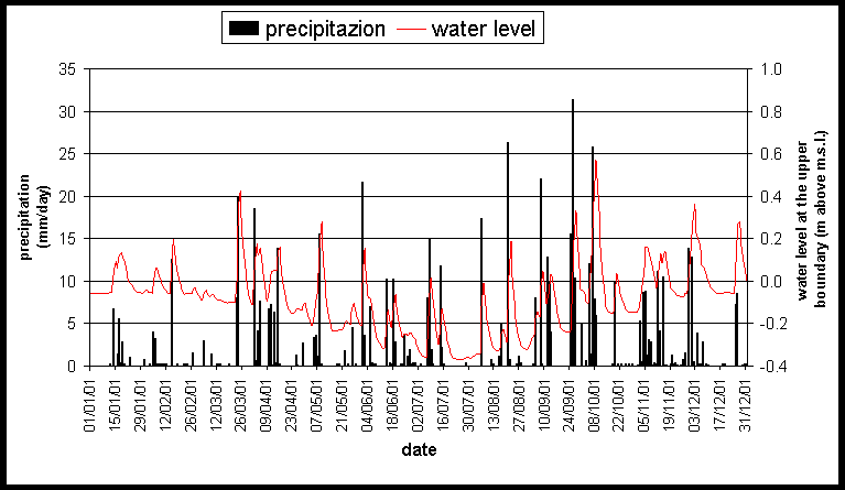
Figure 5. Daily precipitation and water
level at the upper boundary used in the "typical year" flow simulation.
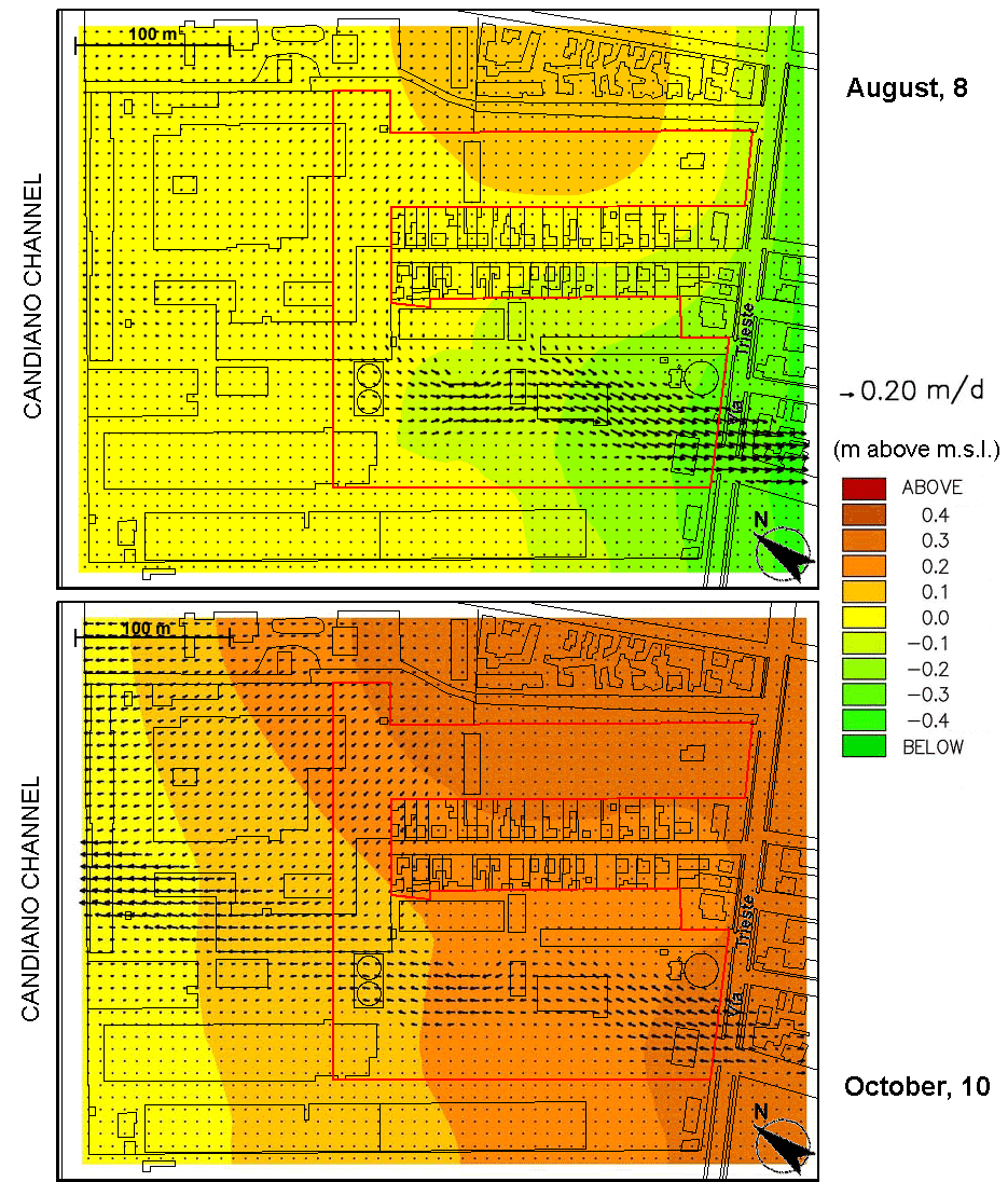
Figure 6. Simulated piezometry (m above m.s.l.) and flow field (m/day) in August, 8 and October, 10 of the "typical year".
High concentration of lead, arsenic, and copper have been detected both in the soil and water samples collected in the study area. The major problem is to evaluate the possible migration of the heavy metals into the channel. With this aim, a set of transport simulations have been addressed, describing the contaminant movement in the subsurface for different scenarios including both normal seasonal variations and extreme events.
General behavior of the contaminant species
The possible mobility of metals in the subsurface is highly influenced by the local geochemical conditions. Two main controlling factor on the mobility are the pH and the redox potential. Around neutral pH, metals are immobile compared to the potential mobility in acid or basic water [4], and reduces species are less mobile then the oxidized species [5]. Change in the redox conditions may occur when a previous anoxic zone becomes oxic. This would be the case when the water table is lowered and oxygen can penetrate further down into the aquifer; when the water table rises these species become dissolved and may migrate with the groundwater. If again the conditions become reduced (as would be the case if the species are transported into an anoxic zone), the previous mobile metals become immobile.
This qualitative behavior has been confirmed by the available aqueous samples collected in winter 1997 and 1998/99. High heavy metal concentrations have been recorded in 1997 in correspondence to a high water table condition; on the contrary, in 1998/99 with the same geochemical setting of the study area, low pollutant concentrations have been measured in a situation of low hydraulic head.
Preliminary advection-dispersion transport simulations
Mainly for arsenic and lead that have a lower affinity for the aqueous phase [6,7], the simulation of the behavior described above would require the knowledge of the distribution coefficient Kd to simulate the reactive nature of the metal with a (linear) isotherm. Due to the lack of data to implement an accurate adsorption/de-sorption model, only preliminary simulation have been run using the MIKE SHE Advection Dispersion module [8]. Hence, model results have been used for the purpose of evaluating the possible "worst" scenario, i.e. if potential conditions for a pollutant migration to the channel subsists.
Two case tests have been run. In the first one, the flow field at October 10 of the "typical year" has been assumed as the stationary forcing factor for the pollution transport. In the second test, recycling on the overall flow result of the "typical year" has been adopted. In both cases a precipitation source of non-reactive pollutant with a concentration of 100 m gr/l has been considered in the center of the investigated area. Longitudinal and transversal dispersivities have been set to 4 and 0.4 m, respectively, accordingly with the available information. For example, Figure 7 shows the pollutant plume in the second test case at a depth of about 4 m after 10 years from the inception of contaminant migration. Results confirm that the possibility of channel contamination exists.
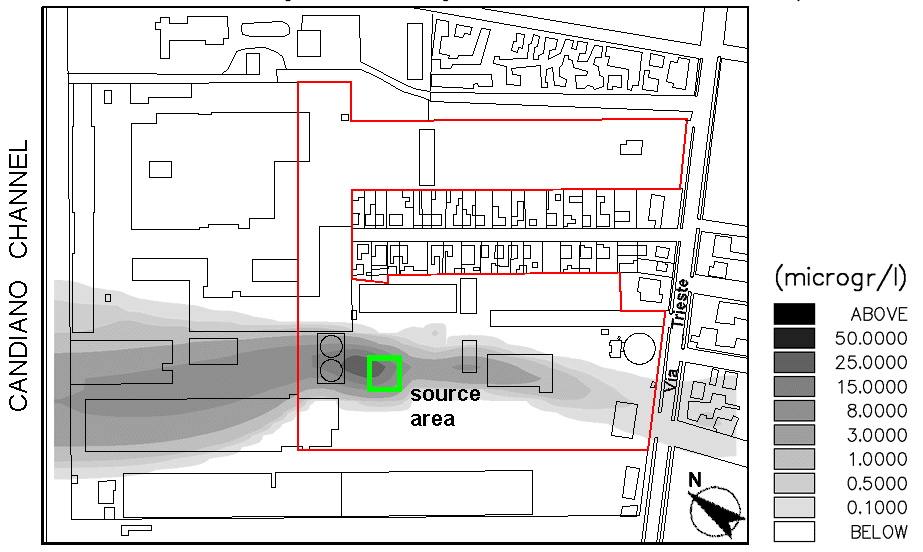
Figure 7. Pollutant concentration at a depth of 4 m after 10 years from the inception of contaminant migration and using as forcing flow field the results achieved with the "typical year" simulation.
One of the possible scenarios to increase the environmental quality of the study area is to treat and make chemically inert the upper 1 m thick layer of the overall remediation area where the contaminants are mainly located. However, problems related to the aquifer are not completely solved by this intervention. First, it is necessary to prevent that residual pollutant, placed at a burial depth greater than 1 m, can migrate toward the channel. Secondly, as the field measurements have shown that heavy metals are present also outside the area planned for the remediation intervention, it is important to isolate the restored zone from the remainder part of the aquifer.
The most effective approach to solve both problems might be the installation of an organic permeable filter in correspondence to the old river bed to remove the contaminant from the groundwater, together with hydraulic plastic diaphragms along the boundaries of the remediation area. The intervention has been verified using the numerical model.
Influence on the piezometric regime
Several configurations of the filter width and barrier depth have been tested in order to evaluate the influence of the hydraulic intervention on the flow natural regime. Although the piezometry is highly influenced by the precipitation and by the more permeable river bed, the simulation outcome have shown that the filter is generally able to keep the water table close to the natural one, with changes of the order of a few centimeters. A typical configuration of the hydraulic intervention is shown in Figure 8.
Influence on the pollution fate
The influence of an organic filter on the pollution migration has been investigated using the Sorption module of MIKE SHE [9] to represent the sorption capability of the filter. A very high value of the distribution coefficient has been adopted to represent the isotherm characterizing the filter.
For example, Figure 8 shows the contaminant plume at a depth of about 4 m after 10 years from the inception of contaminant migration when the precipitation source used in the AD transport simulations is placed just outside the remediation area. The pollutant migration toward the restored area is completely stopped by the filter that adsorbs the metals transported by the aquifer.
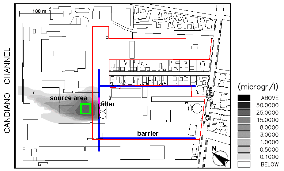
Figure 8. Pollutant concentration at a depth of 4 m after 10 years from the inception of contaminant migration with the presence of the hydraulic intervention to protect the restored area. A typical configuration of the intervention is sketched.
An hydro-geologic and hydro-chemical study of a contaminated old industrial site at Ravenna has been performed by the MIKE SHE simulation package. All the available hydrologic, geological, and chemical data have been used to set up, calibrate, and applied the numerical flow and transport model. Numerical simulations have allowed to achieve the objectives that follow: